|
CCM |
|
GNSS Topics:
About the term GNSS. Some GNSS terminology. About POI and GPX files. Managing GNSS Waypoint Data. |
POI files and GNSS units
|
CCM |
|
GNSS Topics:
About the term GNSS. Some GNSS terminology. About POI and GPX files. Managing GNSS Waypoint Data. |
A Global Navigation Satellite System, GNSS, is, as titled, a system of satellites (in practice 30 or so) that provide timing and location data that a suitable receiver can use to determine its position. The first of these systems was the USA Global Positing System, GPS, and that term became into common usage and is disinclined to be replaced despite the introduction of other GNSS systems. The systems that have been introduced since the GPS include GLONASS (Russian Federation), Galileo (European Union), BDS (China).
In the interest of technological correctness, where feasible, the term GNSS is used here.
In a digital spatial context a track is a digitally recorded path, usually a record of where a person has travelled, though tracks can be generated by other methods.
A waypoint is a record of a single geographical point. It may be produced in the field by 'marking a waypoint' on a GNSS capable device or at the desk by a user interacting with, say, a mapping program. As well as position data, waypoints can have date and time data, an identifying name and a description associated with them.
A waypoint that someone believes is worthy of the status may be called a point of interest, POI.
A route is a sequence of waypoints leading (presumably) from one place to another. In Australia 'route' is pronounced 'root', in some other parts of the world it is pronounced 'rowt'. There is no further discussion of routes on this page.
GPX files carry geographic position data – waypoints, tracks, and routes. GPX files are the default standard for transferring those data, typically between GNSS capable devices and application programs.
A georeferenced image of, say, an aerial photograph or a map, contains metadata defining its scale and geographical location. A suitable application program can display the image in a geographical context; perhaps, for example, relative to another georeferenced image.
The image below is a line from the CCM Welsh Village POI PDF document.

Each line represents a POI The leftmost column is the identification label. The next three columns provide the location as a full UTM reference and the column headed "Map Reference" is a 6 figure version of the UTM reference. The UTM system is discussed in the "UTM grid basics" appendix. The rightmost column is a brief description of the POI.
A POI GPX file carries the same (and a little more) data than the corresponding PDF file but in a format that can be read by computer application programs or apps.
There are a number of things you can do with CCM GPX files. One is to simply ignore them and navigate with hardcopy map and magnetic compass – an excellent choice for competent walkers. However, GPX files can be loaded into handheld GNSS units to be used as a navigation aid. In this case a hard copy of the PDF document discussed above could assist as the POI comments may be more accessible in print than a handheld device. The method of loading the GPX file depends on the brand and model of the GNSS unit.
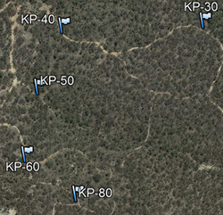
GPX files can be displayed in Google Earth Desktop. The image to the right is a snip from Google Earth Desktop with the Kalimna Park POI file loaded. Download the Kalimna Park POI file from this website and then in Google Earth Desktop select File –> Open and pull down the menu in bottom-right of the Open dialogue box and select Gps(sic) (the third menu item) and follow the normal file selection procedure.
The Atlas of Living Australia (ALA) is a digital and open infrastructure that assembles Australian biodiversity data from multiple sources and presents it in readily accessible manner. The ALA data is publicly available without registration, however you need to register and thus have an ALA user account to upload data. Registration is straightforward. Landcare groups may use ALA to publish the results of their assessment projects. A group may download a spreadsheet template from ALA, load the biodiversity data onto the template and then submit (once was) template to ALA for inclusion into the accessible data set.
The accepted standard for transferring GNSS data from a software or hardware entity to another software or hardware entity is the GPX file. However GPX files are not readily manipulated into structured data sets that include additional information (such as that required by ALA) to the basic waypoint data. Spreadsheets are ideally suited for the construction of data sets of this form. (The processes described here have been trialled on Microsoft and OpenOffice spreadsheets.)
Spreadsheets do not generally have the facility of importing and exporting GPX files. Fortunately GPS Visualizer provides online facilities that facilitate importing and exporting of GPX files. For a guide on how to transfer GPX file data into and out of spreadsheets download gpx_spreadsheet.zip, unzip into a clean folder and open gpx_spreadsheet_tutorial.htm.
The method described in the previous paragraph cannot be used directly with ALA template spreadsheets because of conflicts in column allocation. A workable approach would be to manipulate and compile GPX file data on an intermediate spreadsheet and then selectively copy and paste the data to the ALA spreadsheet.
There is no shortage of programs available for editing GPX files to include, delete or modify waypoints or tracks. CCM has used GPS Utility and EasyGPS with success.
The "Humanitarian Field Guide to GNSS Technology" is a 6 page PDF document that covers GNSS basics, waypoints, tracks, scale, coordinate systems, and datums. It discusses the interaction of GPX files and GNSS data with Google Earth Desktop. It includes links to a Mapping and GNSS Appendix. Although principally directed to field humanitarian workers it may be of interest to technically inclined bushwalkers.