|
CCM |
Me t c a l f e N C R
|
CCM |
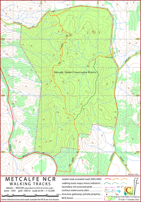
This CCM topographical map covers the Metcalfe Nature Conservation Reserve south of Metcalfe. The area is notable for its hilly contouring (including the classic The Ridge Track). An informed colleague describes the reserve as:
‘A grassy woodland featuring Grey Box, Yellow Box and some exceptionally big Long-leafed box eucalypts. It’s unusual for this region, in that there are few if any Red Stringybarks.’
The intended hardcopy format (as PDF) for the map is A4.
Information on the use of the KMZ and GPX files below with GPS units and Google Earth can be found via the Appendices dropdown menu in the header menu.
There is little opportunity for confusion, the major roads are well signposted.
Bernard Slattery, Friends of Box-Ironbark Forests, for drawing the area to my attention to the Metcalfe NCR and for the description of the woodland.
27/10/2023 – Earliest field data.
| Single-sided PDF map for printing at A4 (< 300 kB) | Download | KMZ file (< 5 MB, 12 tiles) | Download |
| Some points of interest as GPX file (< 5 kB) | Download | Listing of above POIs as PDF file (< 100 kB) | Download |
| OziExplorer file set (details) (< 3 MB) | Download | Geo-PDF file (< 2 Mb) | Download |