|
CCM |
Mu c k l e f o r d
No r t h
|
CCM |
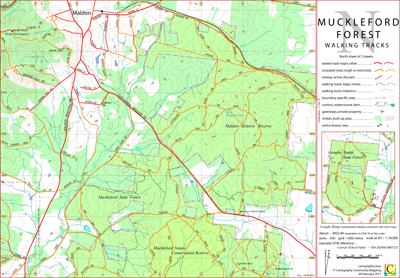
The Muckleford Forest North map sheet covers the entirety of the Maldon Historic Reserve which lies between the Castlemaine–Maldon Road and the Castlemaine–Maldon railway track, and consequently will serve as a stand-alone map for that area.
The map sheet includes a Goughs Range State Park insert. The scale and cartographical details of the insert match those of the main body map.
The intended hardcopy size for this map is A3.
TAIT TOWN TRK [DELWP] is signposted TATT TOWN TRK at the northern end. The western end of TAIT TOWN TRK [DELWP] is signposted (and shown on the CCM map) as RAILWAY TRK. GOWER TRK [DELWP] is signposted GOWAR RD. The CCM map scripts the items as signposted.

There is a JAMES TRK (north sheet) and a JAMIES TRK (crosses over sheets), however the southern end of JAMIES TRK is sign posted JAMES TRK. At some locations there are effectively two RAILWAY TRKs running side by side. An eastern section of PIPELINE TRK is signposted RAILWAY TRK. There is a SOUTH GERMAN TRK (south sheet) and a SOUTH GERMAN RD (north sheet).
05/12/2016 – Earliest field data.
14/04/2017 – Notation changes: 'CFA Tower' corrected to 'DELWP Tower', 'Maldon Heritage Reserve' corrected to 'Maldon Historic Reserve'.
04/05/2017 – Increased minor track detail. Road and track detail in vicinity of Goughs Range Rd included. 07/07/2017 – Increased minor track detail in vicinity of Dunns Reef included.
22/07/2017 – Further minor 4WD track detail included. Map subtitle is now "Walking Tracks".
15/08/2017 – Goughs Range State Park details included as insert. The scale and other presentation details match those of the main body map.
02/09/2019 – Increased track detail at east end of railway line. Increased overlap with South Sheet.
21/09/2019 – Two tracks in Goughs Ranges upgraded. Minor track error corrected.
20/09/2022 – Cosmetic changes.
| PDF file for printing at A3 (0.5 MB) | Download | KMZ file (insert not georeferenced) (9 MB, 20 tiles) | Download |
| Some points of interest as GPX file (21 kB) | Download | Listing of above POIs as PDF file (100 kB) | Download |
| OziExplorer file set (details) (< 8 MB) | Download | GeoPDF (insert not georeferenced) (< 3 MB) | Download |