|
CCM |
Wa a n y a r r a
|
CCM |
This CCM topographical map covers the north-eastern component of the Waanyarra Nature Conservation Reserve and the Waanyarra State Forest between Tarnagulla and Dunolly, Victoria, Australia. To the east it borders the CCM Nuggetty Gully map and to the south it borders the Almeida map. It shows access to Morton's Welcome Inn, the Waanyarra camping area and just across the road, so to speak, the Waanyarra Cemetery.
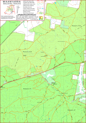


The intended hardcopy format (as PDF) for the map is A3.
A (clickable on screen) A4 PDF file showing the locations of the 4 maps from the Waanyarra set is available.
Information on the use of the KMZ and GPX files below with GPS units and Google Earth can be found in the Appendix panel of the header menu.
In general, in dry conditions, it would be reasonable to interpret the classification, "4WD", as "good ground clearance". There is fallen timber as a result of the June 2021 wind storm across some tracks, generally it can be avoided.
The southern ends of Weed Track and Curley Track have been renamed at various times. Thorpe Track exits and renters the map on the eastern edge; it is contiguous between these points. Sammy Track and Thorpe Track intercept a few hundred metres south of the map edge.
04/04/2023 – Earliest field data.
16/12/2023 – Corrected errors in IDs in POI, GPX file.
| Single-sided PDF map for printing at A3 (< 0.4 MB) | Download | KMZ file (< 7 MB, 20 tiles) | Download |
| Some points of interest as GPX file (< 10 kB) | Download | Listing of above POIs as PDF file (< 100 kB) | Download |
| OziExplorer file set (details) (< 3 MB) | Download | Geo-PDF file (< 2 Mb) | Download |