Cartography Community Mapping, CCM, provides topographical maps of many public access areas in Central Victoria, Australia. The maps are intended for use by bushwalkers.
Graphical Indexes to Central Victorian CCM maps
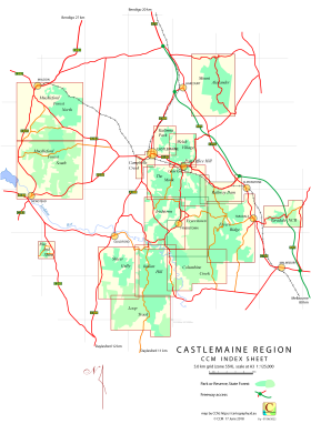
Castlemaine Region Index Sheet is a PDF file for viewing on line or for downloading and printing at A3.
It does not include the Paddy Ranges State Park and the Waanyarra Nature Conservation Reserve maps.
Central Victorian Outlines is a KMZ file that opens in Google Earth.
It provides the outlines of all the CCM Central Victorian topographical maps overlaying the Google Earth terrain image. Clicking within a map outline will provide access to the corresponding CCM web page.
The Castlemaine Diggings National Heritage Park
The Castlemaine Diggings National Heritage Park, CDNHP, stretches some 25 kilometres north to south. CCM provides seven topographical maps that cover the bulk of the CDNHP.
These topographical maps show access roads, walking tracks and other features. The basic file format for these maps is PDF intended for printing at A3.
In addition there are digital versions (KMZ, OZiExplorer and geoPDF) available each map.
Further detail about these maps is available on the Castlemaine Diggings Index page.
West of the Loddon River
Waanyarra is a historic mining town north of Dunolly, Victoria, Australia.
The Waanyarra map provides a guide to access parts of the Waanyarra Nature Conservation Reserve and the Waanyarra State Forest.
Tarnagulla is a historic mining town to the west of Bendigo, Victoria, Australia.
The Tarnagulla map provides a guide to access parts of the Waanyarra Nature Conservation Reserve and the Lanelly State Forest.
Nuggetty Gully is a region south of Tarnagulla, Victoria, Australia.
The Nuggetty Gully map provides a guide to access parts of the Waanyarra Nature Conservation Reserve and the Tarnagulla State Forest.
Almeida is a region east of Dunolly, Victoria, Australia. The dominant historic item in this region is the Almeida Shoot (reef) and the associated tracks.
The Almeida map provides a guide to the Almeida region the bulk of which is covered by the Waanyarra State Forest.
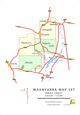
An interactive index to the four maps above is available on the Waanyarra Map Set page.
Paddys Ranges State Park is to the south of Maryborough, Victoria, Australia.
There are two Paddys Ranges State Park maps, an overall map and a more detailed, central map.
The overall map includes a locality insert.
Other Topographical Maps
The Campbells Creek Track is south of Castlemaine, Victoria Australia.
The Campbells Creek map shows a walking and cycling track that follows the creek from Castlemaine to Campbells Creek.
Fryers Ridge is positioned between Taradale and Fryerstown, Victoria, Australia.
The Fryers Ridge map covers the major part of the Fryers Ridge Nature Conservation Reserve.
Metcalfe is south of Bendigo and east of Castlemaine, Victoria, Australia.
The Mount Alexander map provides a guide to walking tracks, access roads within the Mount Alexander park.
Mount Alexander is south of Bendigo and east of Castlemaine, Victoria, Australia.
The Mount Alexander map provides a guide to walking tracks, access roads within the Mount Alexander park.
The area known informally as Muckleford Forest, is west of Castlemaine, Victoria, Australia. It is composed of the Maldon Heritage Reserve, the Muckleford State Forest and the Muckleford Nature Conservation
Reserve. CCM provides a Muckleford Forest map in two sheets.
The Post Office Hill Reserve is at Chewton, Victoria, Australia. The Post Office Hill Reserve
map (including a locality insert) provides a guide to access roads, and features within the reserve.
Railway Dam is positioned to the west of Elphinstone , Victoria, Australia.
The Railway Dam map covers an area to the north of the CCM Fryers Ridge map and to the west of CCM The Monk map.
Its small size belies its complexity.
The Rise and Shine Bushland Reserve is south of Newstead, Victoria, Australia. The Rise and Shine
(including a locality insert) provides a guide to walking tracks, access roads, and other features within the reserve.
The Taradale Nature Conservation Reserve is to the east of Taradale, Victoria, Australia.
The Taradale NCR map provides a guide to walking tracks within the Reserve and the adjacent Metcalfe State Forest.
